Thursday, July 31, 2014

Will Transcarpathia Be the Next Donetsk—or Crimea?


Even as the actual territory controlled by the pro-Russian puppet states of the People’s Republic of Donetsk and the People’s Republic of Lugansk in eastern Ukraine shrinks under pressure from the advancing national Ukrainian military, the fictive super-state of which these rebel provinces are a part is sounding cocky and thinking of expanding.

Pro-Kremlin separatists call the light-blue-colored oblasts in this map a federated Novorossiya.
Transcarpathia (Zakarpattia) is at the far west.
The foreign ministry of the Union of People’s Republics of Novorossiya (that term meaning “New Russia”) (formerly the Federal State of Novorossiya)—the federation that includes the Luhansk and Donetsk oblasts (provinces) as well as six other Ukrainian oblasts where rebel republics exist only in name or not at all—agreed in a meeting in Yalta, Crimea, on July 6th and 7th, to accept as a member the so-called Republic of Podkarpatskaya Rus’.  A new pro-Russian organization called the People’s Front for the Liberation of Ukraine, Novorossiya, and Transcarpathian Rus’ released a manifesto at that conference.

Pyotr Getsko (left), “Chairman of Government Minister” (sic) of the Podkarpatskaya Rus’
“republic,” with Vladimir Rogov, chairman of the foreign-affairs committee
in the Novorossiya “parliament.”  At left is the current Transcarpathia oblast flag, also used by
separatists and nationalists, while the flag on the right is that of the Donetsk People’s Republic,
though the center blue stripe is so washed out that I first mistook it for the black, white, and red
tricolor of the former German Reich (and, briefly, the Third one).  Thanks to a reader who pointed
this out to me on the “Flags of the World (FOTW)” Facebook group.
Transcarpathian Rus’ the Ukrainian government calls Zakarpattia oblast, in its far west.  Rus’ refers to Kievan Rus’, the Medieval state based in Kyiv (Kiev, for Russians) which both Russian and Ukrainian nationalists (and Ruthenian ones; see below) regard as their ancestral state.  The Carpathia part refers to the mountain range that separates the province from the rest of Ukraine to the east.  Variously known as Podkarpatskaya, Subcarpathia, or Transcarpathia, the territory’s Pod- (meaning below) and Sub- prefixes refer to the territory’s position on the Carpathians’ foothills (as in the name of the adjacent voivodeship (province) of Poland, Podkarpacie), while Trans- refers to its position “across” or “on the other side of” the Carpathians—a point of view that implies (as with Transnistria) the perspective of Moscow or Kyiv, rather than Vienna or Budapest.  And indeed, Transcarpathia used to be part of the Austro-Hungarian Empire under the Kingdom of Hungary’s administration.  Slavic-speaking locals called Ruthenians, Ruthenes, or Rusyns tried to establish their own state when the Hapsburg empire was being dismantled at the end of the First World War, but had to settle for becoming the eastern tail of the new-born oblong composite state of Czechoslovakia.  When the Czech portion of Czechoslovakia succumbed to annexation by Nazi Germany in 1938, Slovakia and Ruthenia declared independence but were soon consumed by the Third Reich as well.  After the Second World War, the Yalta conference (not the one referred to above, but the other one, the big one) awarded Transcarpathia, as it was then known, to the Ukrainian Soviet Socialist Republic.  Josef Stalin proceeded to stamp out Ruthenian cultural identity, declaring Rusyn a mere dialect of Ukrainian.  Ruthenians demanded an autonomous region like Crimea’s when Ukraine became independent in 1991 but did not get one.  A declaration of independence in 1993 as the Republic of Subcarpathian Rus’ got nowhere, nor did a similar declaration in 2008 as the Republic of Carpathian Ruthenia.  That second one was strongly suspected by the westward-leaning Ukrainian government of the time to be a result of Kremlin pot-stirring; this, of course, was around the time of Russia’s expansionist South Ossetia War in Georgia.

How today’s Ukraine was divvied up before the First World War.
Transcarpathia has not been a particular hotbed of anti-Kyiv feeling, not does it have particularly many ethnic Russians, compared to all the other oblasts Novorossiya claims.  But this blog did suggest the tiny  province, as long ago as early March, as a future point of conflict between pro-Kyiv and pro-Moscow forces, a point I reiterated in another article, in early April.  (See also an article in which I report on Russian analysts’ predictions for an independent Transcarpathia by 2035.)  In particular, two factors make this enclave an inviting morsel for omnivorous Novorossiyan map-drawers, and indirectly perhaps for the Kremlin itself.  The two factors are demographics and geography.

A Transcarpathian flag (current oblast flag) at this year’s Novorossiya summit in Yalta.
First, demography.  Transcarpathia is more than 80% ethnically Ukrainian and less than 3% ethnically Russian, with Rusyns (Ruthenians) making up less than 1%—only about 10,000 people.  But this belies a possibly larger number of families of Rusyn descent who assimilated to Ukrainian and Russian culture and language in the Stalin era and may only now be dusting off their old ethnic identities.  Russia may be intending to use supposed oppression of Rusyns as a pretext for intervention, much as it did to “protect” Abkhaz and Ossete “victims” in Georgia in 2008 and ethnic-Russians in Crimea earlier this year.  (Compare also the Russian-speaking political forces in Latvia which have piggybacked their cause onto the question of autonomy for the traditional Latgalian people who live in the ethnic-Russian-dominated areas of Latvia.)

Are Transcarpathian Ruthenians ready for their ethnic revitalization?
Or does Moscow just wish they were?
More to the point, 12% of Transcarpathia’s 1.25 million or so people are ethnic Magyars (Hungarians), making them the largest non-Russian ethnic minority in Ukraine in any single oblast.  (Ukraine has more ethnic Belarussians and Moldovans (Romanians) than Magyars when taken as a whole nationally—but these other groups are more dispersed (though 20% of the less populous and smaller Chernivtsy oblast nearby call themselves Moldovan or Romanian).)  Concern for the Transcarpathian Magyars’ “plight” has become an obsession of Jobbik, the militant far-right party of xenophobes and anti-Semites that took more than a fifth of the vote in Hungary’s elections this April, making it the second most powerful party in that country.  Jobbik bloviators have been pushing Budapest to annex Transcarpathia if necessary to “protect” ethnic kindred there.  A lot of the rhetoric focuses on the Ukrainian government’s revocation of minority languages’ official status after Ukraine’s pro-Moscow president, Viktor Yanukovych, was impeached in April.  Even though the successor government quickly reinstated those rights, the original revocation is still Exhibit A of those, like the Donetsk and Lugansk rebels, who claim the current Ukrainian government oppresses minorities.  The fact that the armband-wearing, goose-stepping thugs of Jobbik and the southeastern “people’s republics” are working from the same playbook helps put the lie to Moscow’s lunatic assertion that it is the “junta” in Kyiv who are the right-wing extremists and neo-Nazis.

The far-right group Jobbik is the second-largest political party in Hungary.
Now to the geographic factor, which concerns central and western Europe’s dependence on Russia’s natural gas (hence the European Union’s toothless and half-hearted sanctions against Russia since the Ukrainian troubles began).  Russia’s president, Vladimir Putin, would like to keep the gas flowing to Europe, but he would also like to be able to cut off the supply to Ukraine if necessary to bring it into line.  The trouble is the oil pipelines to western Europe for the most part run straight through Ukraine, and most of these go through tiny Transcarpathia in particular.  And Transcarpathia’s border with the Slovak Republic—an E.U. member-state friendly to Kyiv—is one of the few places where the pipelines could be used to send gas back into Ukraine as a way of making an end run around any plans by Putin to choke off Ukraine’s supply.


Could Putin or the Russian-speaking thugs in Ukraine make an actual grab for Transcarpathia?  Not likely.  They weren’t even able to turn independence declarations into “facts on the ground” in two other oblasts—Kharkiv and Odessa—where the demographics tilt toward Russians.  (The so-called Odessa Republic of Novorossiya declared with little effect in late April granted diplomatic recognition not only to the Kharkov, Lugansk, and Donetsk people’s republics but, a little mysteriously, to what its “foreign ministry” called the Carpathian Ruthenian People’s Republicas reported at the time in this blog.)  Those areas are firmly under Kyiv’s administration.  But many observers feel that Putin may not really want to annex any other chunks of Ukraine, that he would be happy to destabilize it and weaken its central government through agitation for federalism.  And an invasion and annexation of Transcarpathia is not entirely impossible either.  After all, a mere year ago anyone who predicting a Russian invasion of Crimea, Donetsk, and Luhansk would have been laughed out of the room.  Ukraine’s war with Russia has not yet been won.  Not by a long shot.

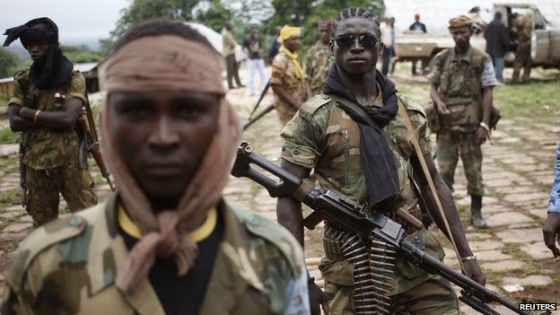
The scene in Donetsk.  Could conflict spread to Transcarpathia as well?


[You can read more about these and many other separatist and new-nation movements, both famous and obscure, in my new book, a sort of encyclopedic atlas just published by Litwin Books under the title Let’s Split! A Complete Guide to Separatist Movements and Aspirant Nations, from Abkhazia to Zanzibar.  The book, which contains 46 maps and 554 flags (or, more accurately, 554 flag images), is available for order now on Amazon.  Meanwhile, please “like” the book (even if you haven’t read it yet) on Facebook and see this interview for more information on the book.]


Monday, July 28, 2014

South Africa Hears “Boer State,” “Winnie Mandela Province” Proposals


In South Africa, the Boere-Afrikaner Volksraad (“people’s council”), or B.A.V., which represents white South Africans of Dutch ancestry (known as Boers or Afrikaners), said this month that South Africa’s government had provisionally agreed to discuss the possibility of a new province designated for Afrikaners.

Former Boer and Griqua (mixed-race Afrikaner) republics in what is now South Africa.
As the chairman of the B.A.V., Andries Breytenbach, points out, the idea of a Boer state is not new: “It’s not a new thing for us.  The Voortrekkers left the Cape in 1834 to establish their own republics, and became full players in the international world.”  The Boer republics he is referring to—the Republic of Stellaland, the State of Goshen, the Transvaal Republic, Orange Free State—were not exactly full international players: in fact, they struggled for any diplomatic recognition at all.  Eventually, over the course of roughly the 19th century, these quasi-independent Dutch colonies were absorbed by the United Kingdom’s colonial regime—first, as a way of preventing France from encroaching into southern Africa after Napoleon Bonaparte’s invasion of the Netherlands, and then later more comprehensively in the Anglo-Boer Wars.

Andries Breytenbach
Breytenbach makes no bones about the fact that the ultimate goal is not just something along the lines of KwaZulu–Natal, a South African province which is majority Zulu and named for the traditional Zulu kingdom but otherwise simply one of nine provinces of equal status.  The B.A.V. wants an autonomous region, and eventually an independent state.  Afrikaners, he explained, naturally wish to be governed by Afrikaners. After all, he said, “Germans want to be governed by Germans, Japanese people want to be governed by Japanese”—though he could perhaps have chosen two examples with slightly different resonances if he is wishing to win people over to his argument.  After all, the Boers were the architects of apartheid, the cruel system of racial segregation and disenfranchisement which they imposed after the Second World War—mainly out of anger at the then-ethnic-English-dominated government’s decision to join the Allies in the war instead of the Axis powers that Boers tended to sympathize with.

The flag of the Afrikaner Weerstandsbeweging, or Afrikaner Resistance Movement,
betrays modern Boer nationalism’s roots in pro-Nazi sympathies.
After apartheid ended in the 1990s, groups like the Pro-Afrikaner Action Group (Pro-Afrikaanse Aksiegroep, or PRAAG), the Boerestaat Party, and the Freedom Front (Vryheidsfront, or V.F.), proposed setting aside a large swath of the Cape region in western South Africa as an independent Boer republic.  (It is V.F.’s proposal for a Boer state’s boundaries which is shown at the very top of this article.)  But such notions had no chance in the face of the sheer momentum of Nelson Mandela’s optimistic, unifying vision for a new South Africa.  More recently, two Boer micronations of sorts have been established—Orania, in Northern Cape Province, and Kleinfontein, just outside Pretoria—are seen by some as the kernel of some future Afrikaner Volkstaat.  This is especially true of Orania, which even mints its own currency.

F. W. de Klerk, a Dutch-descended Afrikaner, handed the South African
presidency to Nelson Mandela in 1994.
More spectacularly, a militia called the Boeremag was in 2003 on the brink of carrying out a plan to assassinate President (as he then was) Mandela, after which they hoped to seize power and reinstate apartheid, before they were stopped by the authorities.  Some Boer nationalists follow the prophecies of a semi-literate mystic from Transvaal named Siener van Rensburg who gave clairvoyant advice to Dutch generals in the Boer Wars and whose visions seem to portend an eventual independent Boer republic.

The official flag of the white-supremacist micronation Orania
One would think that such an idea would be dead in the water.  Although one survey found that 56% of self-identified Afrikaners would consider moving to an autonomous Boer state, Boers are nonetheless only 6% of the population and are outnumbered by mixed-race and Black South Africans who speak Afrikaans (the South African dialect of Dutch) and are mostly dead against any kind of revival of apartheid, even of the voluntary sort.  But South Africa’s president, Jacob Zuma, has said that he intends to meet with the B.A.V. next month to discuss the idea—not of independence but of some sort of internal reorganization that will provide a homeland.  Zuma addressed the issue of Boer identity in an interview in 2011.  Though he stated, “You can’t create an Orania, you must be part of South Africa and share in what we all share,” he also acknowledged that, as with any ethnic group, some sort of homeland “is what some Afrikaners need on a psychological level.”

President Jacob Zuma
This could mean anything from just redrawing some borders and declaring a province with a Dutch name, or even a kind of autonomous region.  As Breytenbach put it, “It may not be in just one area, but two or three.  Because the Afrikaner is spread all over.  One might be around Pretoria, another in the Northern Cape.”  The more he talks about it, the more it sounds like the nominally independent but in actuality very Indian-reservation-like “homelands” or “Bantustans” that the apartheid regime set up as a way of demographically removing Blacks and their tribal allegiances from the South African body politic.  Armed Boer militants even aided one homeland, Bophuthatswana, in its desperate attempt to retain its “independence” when the homelands were dissolved at apartheid’s end in 1994.

When Bophuthatswana tried to keep its “independent” status as apartheid ended,
armed Boer radicals sided with them—and things deteriorated from there.
Meanwhile, Lotta Mayana, chairman of the Cape Town–based human-rights group Sobahlangula, has his own idea for a new South African subdivision: Winnie Mandela Province—to be named for Nelson Mandela’s former wife, a prominent (and controversial) anti-apartheid activist.  The name would be a way of honoring women in general, Mayana said, but mostly he sees economic benefits in merging the current Western Cape, Eastern Cape, and Northern Cape provinces, though he was vague about how exactly that would create more opportunity.  Before 1994, roughly the area of those three provinces was the vast Cape Province, which took up nearly half of South Africa’s territory, back when there were only four provinces.


Some of Mayana’s other ideas for Winnie Mandela Province are less savory.  He wants elephants to be openly harvested for body parts that can be sold to China, and he rails against “the Jews who are in control of [Western Cape] province.”

South Africa’s provinces, before 1994 (in inset) and now
So far, both these redistricting proposals have little momentum, but once the Pandora’s box of redrawing provincial boundaries is opened, who knows what ideas might gain followers?

[You can read more about countless separatist and new-nation movements, both famous and obscure, in my new book, a sort of encyclopedic atlas just published by Litwin Books under the title Let’s Split! A Complete Guide to Separatist Movements and Aspirant Nations, from Abkhazia to Zanzibar.  The book, which contains 46 maps and 554 flags (or, more accurately, 554 flag images), is available for order now on Amazon.  Meanwhile, please “like” the book (even if you haven’t read it yet) on Facebook and see this interview for more information on the book.]


Sunday, July 27, 2014

Chorus Grows for Independence for Muslims in Central African Republic’s North


A few months ago in this blog, I reported on a nascent ambition among the Central African Republic’s beleaguered Muslims to split away as a separate independent country.

Governance of the C.A.R., since independence, has swung between different peoples,
in a country where no ethnicity has a majority.
The C.A.R. was not always on the list of countries straddling Africa’s Christian–Muslim divide plagued by militant separatism, a list that has included Nigeria, Kenya, Côte d’Ivoire (Ivory Coast), and the recently-partitioned Sudan.  But in 2012 a civil war broke out along the lines separating the 15% Muslim minority from the 80% Christian majority in France’s former landlocked colony.  (Since 35% are sometimes reported as “animist,” and since followers of tribal religions often belong to an organized religion as well, these figures are fairly approximate.)  Within months, Séléka, the Muslim umbrella coalition, deposed the Christian-dominated government in a coup d’état, but in just under a year, in January of this year, a Christian counter-coup turfed them out.  Reprisals have been particularly bloody, including massacres on a scale that has made some toy with the word genocide and even some fairly well documented instances of revenge cannibalism, including by a young “Muslim eater” nicknamed “Mad Dog.”

The notorious Islamophage “Mad Dog”
As in other civil wars, reprisals have forced the ethnic and religious boundaries on the ground to sharpen, as local minorities flee to areas where their own groups predominate.  For months now, Séléka has effectively sealed off the northern portion of the C.A.R. and is running it as a sort of de facto state, outside government control.  As one Muslim put it back in April, “The partition itself has already been done.  Now there only remains the declaration of independence.”


That may be coming.  General Mohamed Moussa Dhaffane, a Séléka delegate, said on July 22nd at a multi-party conference on the C.A.R. crisis in Brazzaville, Congo, that the only solution to the nation’s strife that can protect Muslims from pogroms is full independence.

Abakar Sabone wanted to bring a partition plan back
from Brazzaville, not another cease-fire
That view was echoed by Abakar Sabone, who heads the Movement of Central African Liberators for Justice (M.L.C.J.).  Sabone, a former Muslim cleric, said that Séléka “represent[s] the Muslim community in the north.  The partition is already effective because all Muslims are now in the north and the current government has no access to the north.  Séléka are voicing what that community in the north wants.”


The Brazzaville summit had a more modest result, however.  All the participants went home with was a half-hearted cease-fire agreement between Séléka and the Christian–“animist” coalition called the “Anti-Balaka movement.”  Left unspecified was how such a cease-fire could be enforced in a country where no one is really in charge.  And shortly after the deal was announced, the Séléka leader Major-General Joseph Zoundeiko (pictured above), who had not attended the conference, told the B.B.C. that he rejected its terms and that his followers would not abide by it.  He demanded instead the immediate partition of the country.


Some C.A.R. Muslims are saying that a full half of the country should become their new state, reflecting not their share of the population so much as the vast areas Séléka held at the height of the civil war (see map above).  Still unresolved, too, is what the new country would be called.  The rather uninspiring Republic of Northern Central Africa has been proposed; I suppose Sélékastan is a possibility as well.  In April, supporters of the idea were circulating a proposed flag, but I have not yet been able to track down such an image.

When Séléka fighters do display a flag, it tends to be the C.A.R.’s national flag.
It is hard to imagine the international community ever sanctioning such a plan.  The Republic of South Sudan next door serving as an illustration of how dividing a country (in that case, the Republic of Sudan, partitioned with the United Nations’ blessing in 2011) between a Muslim north and Christian south can lead to previously unimaginable levels of misery and chaos.  Meanwhile, the United States and other Western countries fear that radical Islamist insurgencies in an arc stretching from northern Mali to northern Nigeria to Kenya and Somalia and Yemen are gradually making common cause with one another under what may eventually be an al-Qaeda banner.  And there is reason to fear that an “independent” state governed by an ill-disciplined rebel army in northern C.A.R. could allow that region to once again become a haven for Joseph Kony and his dreaded Lord’s Resistance Army (L.R.A.).

No one wants to give Joseph Kony a new lawless zone to move around in.
No, the international community, including even and especially the African Union (A.U.), remain steadfastly committed to making Africa’s European-drawn, colonial-era borders sacrosanct—no matter how much suffering ensues as a result.


[For those who are wondering, yes, this blog is tied in with my forthcoming book, a sort of encyclopedic atlas to be published by Auslander and Fox under the title Let’s Split! A Complete Guide to Separatist Movements, Independence Struggles, Breakaway Republics, Rebel Provinces, Pseudostates, Puppet States, Tribal Fiefdoms, Micronations, and Do-It-Yourself Countries, from Chiapas to Chechnya and Tibet to Texas.  The book, which contains dozens of maps and over 500 flags, is now in the layout phase and should be on shelves, and available on Amazon, by early fall 2014.  I will be keeping readers posted of further publication news.  Meanwhile, please “like” the book (even though you haven’t read it yet) on Facebook.]

Efik Monarch, Angry over Bakassi Cession, Seeks Independence from Nigeria


The Efik nation, a traditional monarchy in the southeastern corner of Nigeria which dates to pre-colonial times, has said that it intends to secede from Nigeria, mostly because of anger over last year’s cession of the Bakassi Peninsula to neighboring Cameroon, where Efiks also live.


High Chief Eyo Bassey Eyo-Cobham, chairman of the Eburutu Royal Fraternity Forum, made the announcement at a press conference in Calabar, Nigeria, on June 23rd.  He also cited “undue government interference in Efik kingship,” in the words of one press report, and suspicions that the central government in Abuja is planning on handing even more Efik land to Cameroon.  The current obong (prince or traditional ruler, sometimes translated king) of the Efik city-state at Akwa Akpa (“Old Calabar,” in Nigeria) is Basso Ekpo Bassey II (a.k.a. Ekpo Abasi Otu), who took the throne in 2008.  The larger Calabar (a.k.a. Kalabari) Kingdom, which includes Efiks but is dominated by the Ijaw ethnic group, is headed by Theophilus J. T. Princewill, who became King Amachree XI in 2002 (though Amachree’s rule has been in recent years troubled by competing claims).

Basso Ekpo Bassey II’s coronation in 2008
Nigeria’s Cross River State administered the disputed Bakassi Peninsula until the Nigerian and Cameroonian governments agreed in 2002 to abide by an eventual ruling on the overlap by the United Nations’ International Court of Justice (I.C.J.).  The I.C.J. decided in favor of Cameroon, and in 2006 Nigeria formally ceded the area, to the anger of Efiks who proceeded to declare a Democratic Republic of Bakassi.  In this, they had allies in both the Southern Cameroons National Council (SCAPO), a group fighting for the independence of the formerly British-administered parts of Cameroon—plus Bakassi—and an Ogoni autonomist group in Nigeria called the Movement for the Emancipation of the Niger Delta (MEND).  That declaration never got any traction, since the Cameroonian government cracks down much harder on separatist talk than Nigeria’s does.  In 2012, the Bakassi dispute was rekindled as the ten-year deadline for Nigeria to appeal the I.C.J. decision was allowed to lapse, prompting Efik activists to accuse Nigeria of abandoning their kinsmen in Bakassi to the Francophone-dominated Cameroonian regime.  In that same year (as reported at the time in this blog), the Efik obong openly advocated accepting an invitation to join Southern Cameroons separatists to push for an independent Ambazonia straddling the border.

This map shows the Efik ethnolinguistic group (included here with Ibibio)
in relation to the Igbo (here “Ibo”) and Ijaw peoples.
Regarding the Bakassi cession, High Chief Eyo-Cobham told reporters at the recent press conference, “With such developments and other oppressive acts and tendencies of the Nigerian State, we the Efik Eburutu people say, ‘Enough is Enough,’ and have decided to take our destinies in our hands peacefully by pulling out of Nigeria. Our peaceful aims and objectives of self-determination for full autonomy are in tandem with Articles 1, 3-21 of the United Nations Charter of which the Federal Republic of Nigeria is a signatory.”

Amachree XI, king of Calabar: is he as separatist as the Efik obong?
In an official statement, the monarchy said that the Nigeria has, in one way or another, “turned us [the Efik] into punching bags socially, economically, and politically.”


The Bakassi Peninsula, in the words of the statement, “was an integral part of Efik Eburutu Kingdom as shown in all available records” and “was secretly and heartlessly expunged from Nigerian map in October 1960, filed in United Nations and African Union (A.U.) secretariats and ceded in 1975 to Cameroun without the consent and knowledge of its owners—the kings and chiefs of Efiks of Calabar and Bakassi.  This action has demonstrated that our people are not wanted in Nigeria, and as a people, we do not want to belong to Cameroun.  The effect of this ceding has brought untold pain and sufferings to Efik Eburutu people.  With this, the spirit of our ancestors who were, as it were, buried in the now ceded territory are roaming, refusing to be appeased.”

Efik protesters angry about the Bakassi cession
It is not clear if King Amachree XI has taken a position on this latest statement—i.e., whether this latest move is an Efik initiative only or if it has the support of the larger Calabar Kingdom of which, in a sense, it is traditionally a part.  But it comes at a time of increasing fragility for Nigerian unity.  The Igbo-dominated Biafra separatist movement, which includes Cross River State and other traditional Calabar territories in its claim, has remained active in recent years, the Adamawa monarchy in east-central Nigeria—which also straddles today’s border with Cameroon, but farther north—agitated for separatism earlier this year (as reported at the time in this blog), and the radical Islamist terrorist group Boko Haram has been waging a brutal insurgency for years, killing thousands, in Nigeria’s north and has in recent weeks managed to control a large part of Borno State.

A proposed flag for “Bakassi Free State”
[For those who are wondering, yes, this blog is tied in with my forthcoming book, a sort of encyclopedic atlas to be published by Auslander and Fox under the title Let’s Split! A Complete Guide to Separatist Movements, Independence Struggles, Breakaway Republics, Rebel Provinces, Pseudostates, Puppet States, Tribal Fiefdoms, Micronations, and Do-It-Yourself Countries, from Chiapas to Chechnya and Tibet to Texas.  The book, which contains dozens of maps and over 500 flags, is now in the layout phase and should be on shelves, and available on Amazon, by early fall 2014.  I will be keeping readers posted of further publication news.  Meanwhile, please “like” the book (even though you haven’t read it yet) on Facebook.]

Related posts from this blog:

Friday, July 25, 2014

Tazzies in a Tizzy over Missing Island on Commonwealth-Games Speedos, Reviving Independence Talk


Tasmanians have always been separated from the other Australian states by the waters of Bass Strait, but now a wider gulf has been opened by Australia’s new Commonwealth Games uniforms, which depict a map of the continent-nation without Tasmania.  The state’s premier is furious, and some regionalist activists are even saying the time has come for independence.


Speedo International, Ltd.—the New South Wales–based swimwear company synonymous with minuscule, painfully tight swimsuit bottoms that leave nothing to the imagination of appalled, eye-averting beach-goers worldwide—recently unveiled the design for the athletic swimwear to be worn by Team Australia at the 2018 games in Gold Coast Beach, Queensland.  The suits sport a jaunty tessellation of galloping kangaroos and emus alternating with Australia’s distinctive outline.  But missing is the large island of Tasmania just south of the mainland’s southeastern corner.  (That’s the uniform above, modelled by the Australian swimmer Kotuku Ngawati, displaying her hyper-mobile elbows.)

The flag of Tasmania (the real one; see below)
Nor is this the first such snub.  When the Commonwealth Games were held in Brisbane, Queensland, in 1982, opening-ceremony dancers formed a Busby Berkeley–style map of Australia, and Australia’s smallest state was missing there too.  Thus, Andrew Nikolic, a member of Australia’s parliament representing Bass, Tasmania, calls the new Speedos a “repetitive insult” and has written in pique to the federal minister of sport, Peter Dutton.  Nikolic says Commonwealth Games authorities “should have a good, hard look at themselves.”  Another Tasmanian legislator, Jacqui Lambie, is demanding compensation in the form of an extra $5 million (Australian) in tourism funding.

Brisbane in 1982.  Hmmm ... I don’t see the Cocos Islands either ...
The outspoken Tasmanian avocational historian Reg Watson* calls the latest omission “absolutely appalling,” adding, “This is typical of how mainlanders treat Tasmania and this is why I believe in secession for Tasmania.”   But Watson’s is not usually a voice of reason: the founder of Australia’s annual Anglo–Boer War Commemorative Day, Watson is also a ufologist, a Jack the Ripper aficionado, and an angry advocate of celebrating Tasmania’s British heritage, which he complains has been shouted down by “political correctness” and the rush to please racial minorities, a conspiracy of silence he compares to Nazism and Stalinism.  Watson is even part of a movement by amateur historians to downplay or outright deny the 1804 massacre of indigenous Tasmanians at Risdon Cove.  The last full-blooded Tasmanian Aboriginal died in the late 19th century after a campaign of extermination that was one of the most thorough and pitiless genocides in modern history.


Tasmania’s premier, Will Hodgman, is more sanguine: he calls the new uniforms “utterly un-Australian” and a “disgrace” and demands an apology, but he has also said, “I’m seriously annoyed, but this doesn’t mean we’ll move to secede.”

Tazzies, take heart!  Nothing could ever be worse than
Team Scotland’s uniforms at the 2014 Commonwealth Games in Glasgow.
Aside from genocide, Tasmania is known in the northern hemisphere mainly as the birthplace of the swashbuckling film star and libertine Errol Flynn and of another Hollywood celebrity with ravenous appetites, Warner Brothers cartoons’ “Tasmanian Devil,” who looks nothing like the ratlike, garbage-scavenging Sarcophilus harrisii found throughout the island.  But, within Australia, Tasmanians have a unique identity and have mulled a split before.  Though Tasmanians voted with the largest majority of any state, to join the Commonwealth of Australia in 1901, the Great Depression of the 1930s brought a surge of separatist anger by Tazzies (as islanders tend to be known) who blamed their economic woes on mainlanders.  Tasmanian secessionism has mostly been kept in check by a realization that Tasmania gets much more from the central government in the form of programs and services than it pays in.


Perhaps Speedo-gate will fan the faint coals of Tasmanian separatism again.  If so, those who take the idea seriously will have to wade through a barrage of inevitable randy jokes: because of the island’s vaguely triangular shape, the term map of Tasmania is a slang term for a woman’s pubic hair.  After all, isn’t that supposed to be invisible on a swimsuit?

Maybe this design would mollify would-be separatists:
you can see a little bit o’ map-o’-Tazzie on this one.
* Not to be confused with the other Australian writer named Reg Watson, creator and screenwriter of the squalid 1970s lesbians-behind-bars soap-opera Prisoner, who appears to be some sort of national treasure.
“Queen Bea” and Lizzie Birdsworth stare down
“Old Vinegar-Tits” in an episode of Prisoner

[For those who are wondering, yes, this blog is tied in with my forthcoming book, a sort of encyclopedic atlas to be published by Litwin Books under the title Let’s Split! A Complete Guide to Separatist Movements and Aspirant Nations, from Abkhazia to Zanzibar.  (That is shorter than the previous working title.)  The book, which contains 46 maps and 554 flags (or, more accurately, 554 flag images), will be on shelves and available on Amazon on March 1, 2015.  I will be keeping readers posted of further publication news.  Meanwhile, please “like” the book (even though you haven’t read it yet) on Facebook and see this special announcement for more information on the book.]


[Hear the author of this blog discuss the Cascadia independence movement in OregonWashington, and British Columbia in a recent interview for Seattle’s National Public Radio affiliate station KUOW-FM.  Click here to listen.]

Related articles from this blog:

“Wiradjuri Activists Raise Flag, Proclaim Newest Aboriginal Republic in Australia” (Jan. 2014)
“Lamb Island, off Australian Coast, to Vote on Becoming Republic of Nguduroodistan” (Oct. 2013)
“Hutt River’s Princess Shirley Had Irish Noble Blood, Mourners Learn” (Aug. 2013)
“Housing Estate Splits from New South Wales, Joins ‘Free State of Australia’” (July 2012)
“Founding of ‘Free State of Australia’ in New South Wales Stems from Zoning Dispute” (Nov. 2011)

[Special thanks are due to Alice Crawford and to Seaman Hornblower (not the one portrayed in film by Errol Flynn) for my education in Australian slang.]

Subscribe Now: Feed Icon